The TNTgis software allows you to work with geodata in geospatial databases, which store both spatial features and associated attributes together in records in a database structure. TNTmips supports file-based geodatabases such as ESRI Personal Geodatabase and File Geodatabase as well as enterprise databases such as MySQL Spatial, PostGIS, and Oracle Spatial. You can link to and maintain geodata in the original database tables, which for enterprise databases allows sharing of common geodata throughout an organization. You can also import geodata layers from a geodatabase to a TNTgis Project File, or export your map data to any of these geodatabases.
See also:
Tech Guides on Spatial Databases.
Create styles and legends for linked data
Pop-in DataTips show attributes
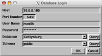
Login control for enterprise databases
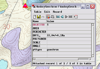
View full attributes for marked elements
Spatial Databases Highlights
- Maintain spatial features and attributes in a relational database
- Transparently share data with other users and software
- Get point, line, and polygon geometries from spatial database tables (one geometry type per table)
- Support for multipoint, multiline, and multipolygon geometries
- Link to any or all of the spatial tables in a database in one operation
- Create a separate link object for each spatial layer stored in the database
- Linked spatial database tables represented as shape objects (ESRI File Geodatabase layers linked as CAD objects)
- Use linked spatial database layers for display or analysis procedures
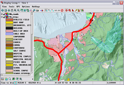
- Display linked spatial database layers with imagery, terrain, or any other geospatial data
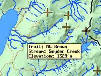
- View attribute information for spatial database layers as tables and in pop-in DataTip
- Perform selection queries on attributes of linked spatial database layers
- Records for selected spatial elements automatically highlighted in spatial database table views
- Select records in spatial database table to mark associated elements in TNTgis spatial view
- Assign styles to elements using associated attributes in the spatial database
- Create map layout legends for spatial database layers with samples automatically generated from attribute-based styles
- Log in to the database only required when first establishing the link
- Option to import spatial database tables as TNTgis vector or CAD objects
- Export TNTgis geometric (vector, CAD, TIN) objects to spatial database tables