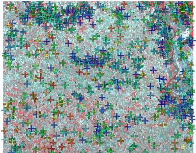
Create hundreds of control points automatically
from reference image using auto-register
Geospatial data that you obtain for your projects may have georeference information that is not accurate enough for your objectives and may contain spatial distortions that require rectification. The Georeference process in TNTmips lets you create, import, or edit georeference information quickly and easily for any type of geospatial data (image or geometric) including external files in many formats. Images and geometric objects with different coordinate reference systems can be displayed together in TNTmips or you can permanently reproject them to a common reference system. You can rectify spatial distortions in images using various georeference models and orthorectify satellite images using an RPC model and a DEM.
See also:
Tech Guides on Georeferencing
and Tutorials on
Georeferencing,
Rectifying Images, and
Orthorectification using Rational Polynomials.
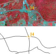
Snap control point to element in reference vector
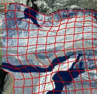
Rectify distorted images
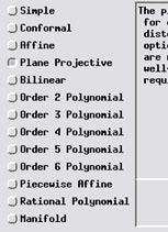
Choice of transformation models
Editing Geodata Highlights
- Georeference spatial objects using reference objects in separate view or as overlays in main view
- Support for thousands of predefined coordinate reference systems or define your own
- Auto-register option automatically generates many georeference control points for an image using a reference image or on-line web tileset
- Control points colored by residual value clearly identify poorly-fitting points
- Snap control points to a geometric reference object or a virtual map grid
- Import control points from GPS files
- Choice of several coordinate transformation models with varied complexity to best match distortion in data
- Set up simple georeference for images with rows/columns aligned to map coordinate axes
- Set up implied georeference for geometric objects containing map coordinates
- Transfer georeference from higher-resolution to lower-resolution bands in a multispectral image
- Create 3D control points for displaying cross-sections and other manifold objects in 3D perspective views
- Rectify/reproject georeferenced images or geometric objects to any coordinate reference system or define your own
- Resample images with choice of nearest neighbor, bilinear, bicubic, and Lanczos methods
- Resample image to match a reference image in orientation, extents, and/or cell size
- Orthorectify satellite images with rational polynomial coefficients and a DEM and refine results using control points
- Create rational polynomial orthorectification model for any image using a DEM and 3D control points